
Genes, Climate, and Even More Maps of the American Nations
Updated, 9/11/15 9/4/15. See below!
Throughout this blog, I’ve talked a lot about the American Nations – a concept, based on a book by Colin Woodard, that North America is divided into several ethno-cultural-political regional “nations”.
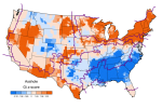
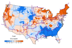
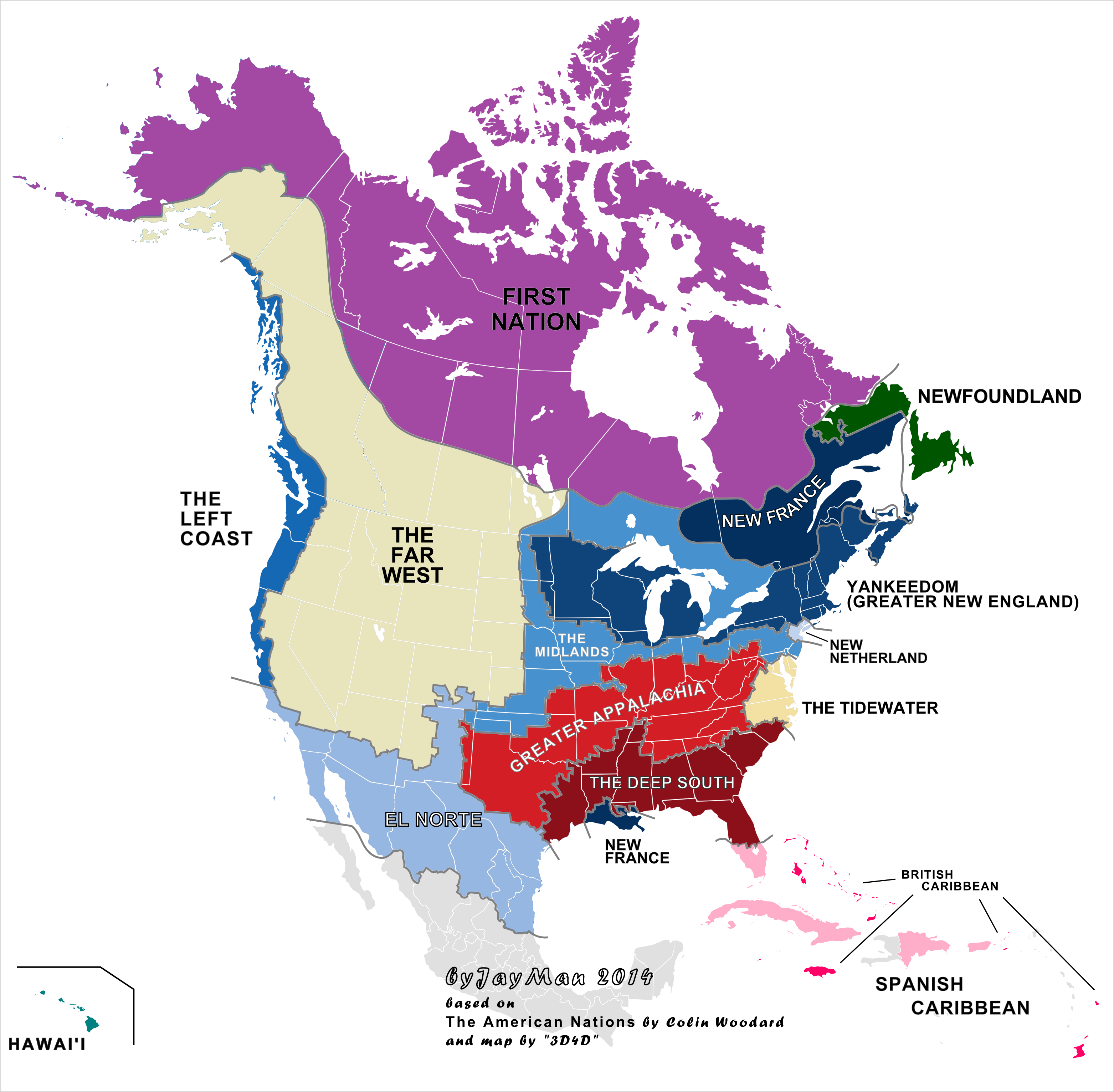 These nations are distributed approximately as shown above. The empirical bases of the existence of these ethno-cultural entities has been covered extensively here; the key posts are indexed on my page American Nations Series. As discussed in those posts, we see these ethno-cultural divisions appear in many different aspects of life: from politics, to language, to crime, [Edit: to guns, see also Guns, violence, and the Dylann Roof rampage and Guns & Violence, Again…,**] to education, to social attitudes (such as on the death penalty, on healthcare, on corporal punishment, on abortion, on the rights of women and gays, and on interracial marriage) Edit: [see also The Rise of Universalism**]. We even see these divisions in allegiance to sports teams, as we see in this map favorite major league teams across the U.S., here baseball:

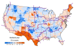
This pattern is also visible when you look at the second most popular baseball team in each county:

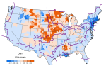
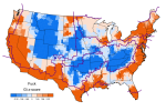
This pattern is also visible with NBA basketball (see also here for Canada):

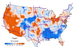
In the case of language, the various American nations also become evident through use of online profanity (as gauged by Twitter):
-
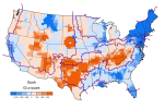
- This seems to correspond to Black areas
-
- Also Black areas.
-
- Primarily Black areas, secondarily Mexican.
-
- The Dixie bloc (Greater Appalachia, the Tidewater, and the Deep South) and perhaps Mormonia in the Far West stand out as exceptions.
-
- El Norte stands out, secondarily French(?) areas of New England
-
- Greater Appalachia (and to a lesser extent, the Far West) clearly stands out
-
- The “Friendly & Conventional” region (Rentfrow et al 2013), a region of German/Scandinavian extraction that has been “boiled down“
-
- Yankee and Midland areas, along with the Left Coast
-
- Pretty much everybody, with the poignant exception of Scots-Irish areas in Greater Appalachia and the Far West
-
- Midlands driven. Perhaps something to do with the Dust Bowl migrations?
Woodard gives an excellent review of the various nations and their histories. He details the course these various nations took towards become what they are today. However, Woodard falls short on the underlying mechanics behind this pattern. Readers here know this to be genetic differences between people living in each region, as detailed in my posts Demography is Destiny, American Nations Edition and More Maps of the American Nations. Behavioral genetic studies clearly establish that regional differences at a given instance stem from heritable differences between the people who inhabit them Edit: [see the aforementioned preceding posts, and see my posts All Human Behavioral Traits are Heritable, Environmental Hereditarianism, and The Son Becomes The Father; recapped in my 200th post, section Heredity and behavioral genetics **]. As such, the question then becomes how did these different strains of people end up where they are? This makes investigation fairly straightforward.
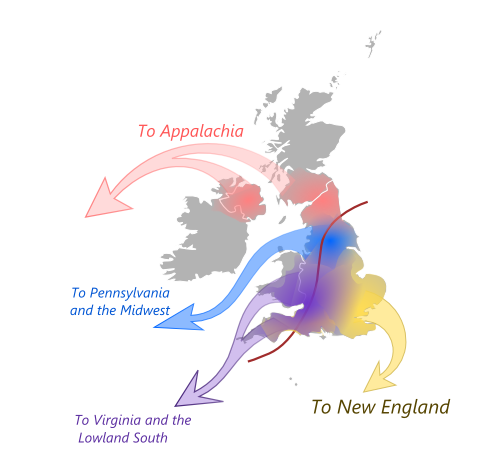
The importance of fine genetic differences between people goes right back to the beginning of the American Nations. Woodard borrows from David Hackett Fischer’s book Albion’s Seed: Four British Folkways in America, which details differences in the founding British settlers and the legacy that leaves today across the various American regions. And, interestingly enough, modern genetic analysis (Leslie et al, 2015) finds that Fischer’s “Four British Folkways” are evident in the genetic data across Britain:

Genetic differences between groups of people, once established, persist as long as the different groups do until diluted or erased by admixture (this is known as the Founder effect). As well, new differences can emerge within a single population as selective migration leads this initial population to fission into two or more daughter populations (see here and here – more on that to follow).
In short, tiny genetic differences between two groups of people can lead to large differences in behavioral traits. This extents to all facets of human behavior – a point driven home by a recent paper correlating linguistic diversity across Europe with genetic diversity there (Longobardi et al, 2015).
But why do the American nations follow the pattern that they do? It turns out that this pattern was hardly a coincidence.
The founding colonial groups landed at various spots across the North American east coast:

From there, the nations spread westward across the continent. However, they did so in a certain way, as the next map will show:
 This is a map of the major climatic zones of North America (from Peel, Finlayson, and McMahon, 2007), with the American nations borders overlain. As we see, there is a tight correspondence between the American nations today and the major climatic zones of the country (something we’ve seen previously in my post Snow Nations):

EDIT, 9/4/15: [Indeed, the American Nations correspond to another climatic factor, overall average precipitation (base maps from Encyclopedia Britannica and The Climate Source, respectively):

 The pattern is also visible (as to be expected) in average annual snowfall (base map from The Climate Source):
 ***End Edit***]
Edit, 9/11/15: [Here also is a map of tree density across North America (from Crowther, 2015):
 As would be expected from climate, the American Nations follow differences in vegetation across the continent. The grassy plains of the agricultural Midlands are evident, as are the dry territories of El Norte and the Far West. The line where the Prairie provinces give way to the taiga of First Nation is clear. The verdant temperate rain forest of the Left Coast is also stands out. ***End Edit***]
Geography dictated the settlement of the country:
 An example of this process can be seen in the settlement of the “upper Midwest” (Hudson, 1986):
 Settlers moved to places where they could easily transplant their way of life. Areas of similar climate obviously aided in that aim. In the upper Midwest, Yankee and Midland settlers were joined by German and Scandinavian immigrants (as detailed in the preceding posts), who were also coming to areas climatically similar to their old homes.
A similar process occurred across the Deep South. Plantation settlements appeared wherever good soil and conditions for cotton farming were to be found. The concentration of Blacks across the core of the Deep South…
 …followed the Cretaceous coastline of North America, 100 million years ago (see Craig McClain):
 This was an area of intense cotton farming, and hence, a high African slave population:


(Retrieved from here)
Agriculture also drove settlement of the middle of country. This area is marked by expansion of the Midlands. The Midlands has been and remains today a region defined by agriculture (map from here):


 Indeed, the Midlands is America’s breadbasket (though the bulk of the crops grown here don’t feed people, but rather serve as animal feed/biofuels). The southwestern extension of the Midlands followed (primarily German) settlers headed down the Santa Fe Trail.
Edit: [Indeed, much of the Midlands possesses a similar geographic character, looking much like as seen in this railroad video shot in southeastern Pennsylvania:
The Midlands looks pretty much like this from South Jersey to Nebraska, with abundant grassy fields throughout.
As well, some observant readers may note that on the climate-American nations map, one disagreement between climatic boundaries and the American nations boundaries is that the climate zone which contains the Midlands, the Köppen “Dfa” zone, spills over into Greater Appalachia. Indeed, this climate zone extends south to the Ohio River. But, in fact, interestingly, so do settlement patterns. The area north of the Ohio River was settled heavily by the principal Midlands ethnic group, the Germans (right map from Fulford, Petkov, and Schiantarelli (2015)):


It’s just that the area just north of the river also received many “Butternut” settlers (primarily Scots-Irish) from the south, making that area a part of Greater Appalachia today. The mixing of German and Scots-Irish settlers in that area is what produces the apparent smooth transition as one moves south from the Yankee-settled areas to the north down through the Midlands and into Greater Appalachia, and finally to the Deep South (which also received a fair number of Scots-Irish). This mixing in the zone north of the Ohio is reflected in the slightly more socially/politically moderate nature of this region relative to the areas south of the river. **]
Similarly, Greater Appalachia expanded with Scots-Irish ranching country. The distribution of cattle in America follows the area of Scots-Irish ancestry (and, secondarily, German ancestry).


 Like their Border Reiver ancestors, the Scots-Irish brought their cowboy culture wherever they went.
Cattle are also popular in some of the German-settled areas of the country. The melding of these two cultures (among other things) gave us certain unique characteristics of the Far West (map from here):
 As for the West, climate clearly played a stark role in the settling of the Far West and the Left Coast. The division between the two nations is clearly visible on the climatic map, the temperate and amenable coast sharply delineated from the arid and highland climates not that far inland.
Here, climate and geography served as the principle barriers. The Left Coast was settled long before the hostile and desolate Far West. The former served as a beacon for the more “civilized” (i.e., non-clannish, see here) settlers from the east. It was only when railroads and other technologies came did the Wild West give way to settlement, becoming the Far West we know today. As previously discussed, both settlements involved distinct sorting events, giving each a unique character that are not as purely governed by ethnic origin as are the nations back east.
The character of the western nations was shaped heavily from migration from the east and the center, as we see in this map of where people in each state were born in 1900:
 The western states were all extensively settled by migrants from the Midlands, and today that is reflected by (among other things) the similarities between the Western accent and the Midlands accent.
The areas of the western Midlands in the Great Plains also served as a secondary source for Western settlers. The wrath of the Dust Bowl sent people pouring from this region – many heading West. Today, the upper central part of the country (the “Friendly & Conventional” zone, according to Rentfrow et al (2013) is in many ways a mirror image of the west (the “Relaxed & Creative” zone – see also Rentfrow, Gosling, and Potter, 2008). The depletion of more liberal-minded individuals has left the Plains a zone of solid “red” politically (even among the less clannish Germans and Scandinavians who inhabit its northern reaches – see also Boiling Off | West Hunter).
To the north and to the south of the United States, in Canada and in Mexico, respectively, we see that climate also served as a barrier. In Canada (as well as Alaska), the matter is straightforward: the harsh wintry climate (as well as the poor quality land which is largely unsuitable for cultivation) limited the extent of White settlers. Native Americans (“First Nations” peoples) maintain majorities in the marginal northerly lands that were less desirable to the European colonists.
In Mexico, the southern limit of “El Norte” is the region where the Mexican desert gives way to wetter, more tropical climes. The northern limit follows the original Spanish settlements along the Rio Grande. Mexicans long maintained a majority in along the U.S.-Mexico border for much the same reason as the First Nations peoples in Canada have: the area was unappealing to Whites (being hotter and drier), and generally remains so today.
Jared Diamond was correct in that geography heavily shapes history. Only he didn’t go far enough. He failed to consider genes. Here we see genes enact their power through the patterns of migration and settlement. Throughout this series, I believe I have made an earnest but nonetheless solid case for the American nations and their ultimately genetic roots. These genetic roots include not only the progeny of the colonial settlers, but the large subsequent immigrant populations that have settled and transformed much of the continent (more so in the nations of the North).
One day, inherited differences will become an accepted cornerstone of human science, much as evolution is for biology generally. In the mean time, tireless bloggers/researchers and others will continue to look into this matter – waiting for the day mainstream science gets over its infatuation with what is effectively creationism.
The theme for the post and this series, from the film In the Electric Mist, a film which represents many aspects of the American nations:


Lovely. I’ve always been fascinated by how the American Nations seem to roughly outline various climatic and geographic zones (especially the division between the Midlands and the far West, which almost perfectly reflects the 100th Meridian, where the Breadbasket begins to transition into a semiarid landscape).
Nice maps, although in some the correlation looks much looser than others.
It would be great someday to see someone write a whole book that explains the connection between human demographic expansions and geography/climate better than Jared Diamond’s “Guns, Germs, and Steel” (and maybe remember genes…). I guess we have to do with this until then!
Not to nitpick the American nations map, and I’m sure there’s plenty of ambiguity along the borders, but as a native of the state, I’d say the Florida division isn’t quite correct. Counties as far north as Sarasota and St. Lucie are classified as part of the Spanish Caribbean, despite having well less than 10% hispanic or Spanish-speaking populations. On the flip side Tampa and Orlando are classified as Deep South, despite having very little cultural or linguistic commonalities with Georgia or Alabama.
To be exactly accurate (though probably too busy to divide on a map of the entire country), I’d say anything North of Orlando is Deep South. Most of Central Florida, particularly along the West Coast is a Midlands exclave (high German ancestry). Given the high Puerto Rican population Orlando should be part of the Spanish Caribbean. Core Tampa is pretty Cuban, but the metro area is relatively white and German, so it probably fits better in the Midlands exclave.